Transport for London propose major Woolwich town centre changes
Transport for London have launched a consultation into changes to Woolwich town centre including dedicated cycle lanes and new crossings near the Elizabeth line station.
Previous documents in planning applications dating from 2022 already gave us a clue on what was planned with the new consultation showing a route from the ferry heading down Powis Street, then north along MacBean Street before heading east along Beresford Street and linking to existing lanes to Plumstead.

No cycle lane is located on Woolwich High Street which would be the most obvious and quickest route from Cycleway 4’s planned end point at Woolwich ferry and Plumstead segregated lanes.
That’s partly because housing developments were approved in recent years lining Woolwich High Street leaving little pavement space and severely hampering the ability for cycling.

A mistake highlighted on this site which Greenwich planners ignored.
I’m not convinced the issue of space couldn’t be alleviated if the will – and funding – is there.

The road was rebuilt here in recent years but almost exactly as it was prior, with two general traffic lanes and a mini roundabout.
TfL do now plan a new westbound bus lane on Beresford Street and Woolwich High Street.

Woolwich High Street may be two lanes on paper but is in effect a one-lane road as things are. Bus stands block traffic (including other buses) while vehicles seem to be allowed to park there day and night given how weak Greenwich Council enforcement is.
TfL are still seeking to keep bus stands here. Surely Hare Street is a better location?

Most buses turn into and start their journeys along Hare Street as it is.
This decision will slow buses heading west through Woolwich such as the 177 and 180 while limiting the most obvious and quickest route for a cycle lane.
Instead of a route past the waterfront leisure centre cyclists are expected to head down Powis Street including through a busy areas for shoppers.

Then turn off past Lidl and along MacBean Street before joining Beresford Street.

Covered market
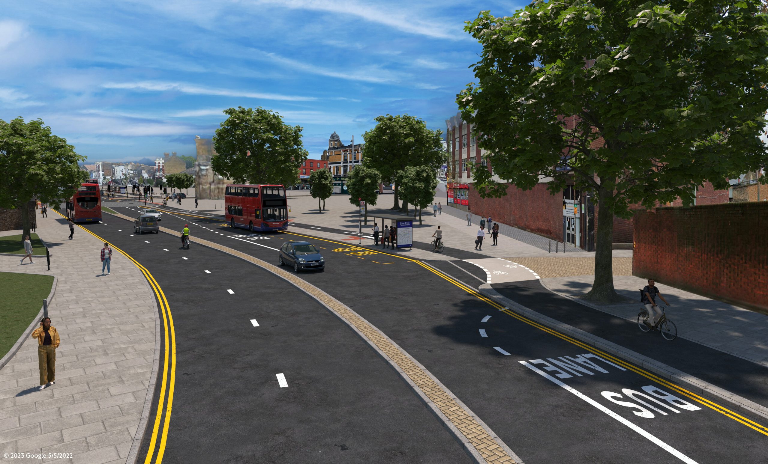
Further east and a new cycle lane is proposed along Beresford Street and then Plumstead Road running along the southern side beside the old covered market and forthcoming Woolwich Exchange development.

Landscaping for the development approved recently took up much space and ignored the potential for a cycle lane. It now appears public realm plans will need to be changed.
It always seemed odd. Why have such extensive raised planters when a cycle lane was probable and very busy bus stops are here?

That’s before increased footfall from over 800 new homes, many new shops and cinema.
It also appears from a few renders that approved schemes as part of the £25 million town centre changes currently underway will have to be altered. One such space may be extensive landscaping near Woolwich market submitted in 2023.

That too limited the option of cycle lanes at this location so it’ll be interesting to see how that plays out with this render from TfL.
Cycle lanes would head past an island bus stop where landscaping is proposed.

Those hoping for fewer lanes near Woolwich stations and a reduction of severance between each side of Woolwich town centre won’t find it in these plans.
The width of the road and central reservation remains.

Up to seven lanes of asphalt remain in place as does street furniture akin to a rural “A Road” than an inner London town centre.
Note also the lane above passes the Royal Arsenal Gatehouse. Again this could conflict with approved plans which saw landscaping at that location.
Crossings
A new pedestrian crossing is proposed near the Elizabeth line station which acts to link the Royal Arsenal and Beresford Square. A separate crossing to be moved a short distance west closer to where Greenwich Council are to build a new market pavilion.
Gone will be part of the £750,000 “super crossing” installed not too long ago. This whole area has been built, dug up and rebuilt numerous times in the recent past.

Landscaping was installed along the central reservation just over a decade ago then removed.
A tree is to be removed for one of the new crossings.

Working together?
Transport for London’s consultation page raises a wry smile when it states: “We have been working closely with the Royal Borough of Greenwich since 2018 to develop projects that would make it safer and easier for local people to walk and cycle”.
So closely it’s taken five years for this to emerge and then the plan goes against changes recently approved by Greenwich Council including major developments and their own £25m town centre revamp just starting.

The same mistake was due to be made at the development pictured above along Beresford Street. It was rejected but not due to a lack of proposed space along Beresford Street.
It’s also highly questionable whether TfL and Greenwich worked closely given almost every time a major development in Plumstead or Woolwich was submitted since 2018 TfL requested funding for town centre improvements.
See this example below from 2022.

Planners blamed viability yet once again managed to find larger sums from Section 106 for other favoured projects while transport saw the rump. It wouldn’t have been so critical if they hadn’t such a poor record obtaining funding via the Community infrastructure Levy instead.
Two weeks later at another major Woolwich development TfL sought 700k. Greenwich planners allocated just £50,000.
Thus minimal funds for improvements has been a common theme for years. Almost every time Greenwich Council’s planners flat out stated “no” or offered minimal sums below what was sought.

Mind you TfL shouldn’t be too offended as Greenwich said the same to Network Rail regarding improvements at Woolwich Arsenal station as well as in response for funds to improve links between homes at a major estate rebuild slightly west.
For years prior they’ve often seemed to loath funding active travel and public realm improvements while expect everyone else to do it for them. They’ve often lagged many other London authorities when it came to contributing towards transport projects within their jurisdiction.
Good news
On the flipside it’s welcome to now finally see plans emerge after thousands of homes have been built with thousands more on the way; many of which are car-free. That does show progress in the relationship between Greenwich Council and TfL. Perhaps a more enlightened cabinet are in place alongside officers.
Sadly some of the mistakes recently made cannot be undone while others may now be halted post-approval yet before implementation. The question is whether this makes the best of what can be done.

I’m not entirely convinced Woolwich High Street couldn’t see lanes. Some cyclists heading westbound will surely use the bus lane anyway rather than take the detour along Powis Street and MacBean Street which are often busy with footfall and cars heading to Lidl.
As for the area between the Arsenal and Beresford Square the lack of meaningful changes will surely disappoint many. That is likely to be a contentious point in consultation responses.

What we see is undoubtedly better than what exists but as good as it could be – or perhaps should be?
Could a compromised design be due to Greenwich Council regularly failing to allocate funding from new developments anywhere close to levels TfL requested? And could TfL not act to ensure space for cycle lanes where peoplemay want them such as Woolwich High Street by relocating bus stands?
To view consultation documents click here.


The illustrated floating bus stop at Beresford Square is far too small for the number of buses that use the current stop it and the passengers who board and alight there.
The 301 does not turn into Hare Street.
Cycling through the Arsenal site is far safer.
Yep the bus stops look narrow given footfall. The 301 is to be extended to Charlton so that shouldn’t be a factor in future in terms of bus stands and Hare Street.
As for cycling through the Arsenal it’s safer but slower. For substantial modal change direct, safe and fast routes are key. When Cycleway 4 ends at the ferry the fastest route east would be a dedicated lane past the Waterfront and then towards Plumstead Road linking to the segregated lanes there. Going indirectly via Powis Street means potential conflict with shoppers and is slower.
The Arsenal site is also set to be see some pretty big changes with 660 homes coming soon. Not sure how that will slow down or impact future cycling.
I suspect they don’t want to sort out Woolwich High Street as it would cost higher sums given each side is on slightly different heights.
It’s certainly fixable but if Royal Greenwich aren’t allocating the funds from new builds then TfL probably lack their own capital budget to do what is needed. A lot of this does highlight the extreme short-sightedness of RBG planners. Greenlighting blocks here and there without much thought of what happens a few short years later. But really isn’t that how they’ve managed Woolwich for decades which is a factor in its long-term decline relative to Bexleyheath, Bromley and Lewisham plus many other London town centres? No strategic plan for the future has been a failure since the 1960s until, well, now. They enact poorly thought out changes then they’re almost immediately shown to be mistakes and redrawn again. And again.
If Woolwich High Street isn’t improved now – and even without a cycle lane one bus lane alone isn’t enough – then when Waterfront closes that’s a perfect opportunity to improve it.
I was going to say you’re being too harsh but then again the past decade has indeed seen many projects implemented which are already being dug up in this part of the borough. Beresford Square market is one obvious one and how this new cycle lane and crossing proposal relates to it is key. I’m not surprised the recently installed crossing to the arsenal is going already as it never really worked. Isn’t it only about 5 years since built! The alteration looks much better though of course a great shame so much spent and wasted in recent years doing the same areas again and again while nearby there’s spots crying out for some TLC and funds.
The parking and bus stands are certainly a pain when I’m passing on the bus and while a new bus lane will help if they simply retain a load of stands in the middle it’ll achieve little. There’s always cars parked along Hare Street so it appears space is possible for more bus stands to remove that bottleneck outside the old riverside house and leisure centre. I will add all this into the consultation but whether tfl have made up their minds remains to be seen.
I do worry the post comes across as too negative and whinging given a safe and quick link will be a great thing.
I’m just conscious that in the recent past many “improvements” in Woolwich have not worked and more mistakes help no one. It’s a good thing already approved public realm changes havn’t been installed outside the covered market and gatehouse/outdoor market as that’d really be a waste if dug up so soon.
A “quiet way” along Powis Street and MacBean Street can certainly work but it does go through a busy shopping area particularly around Iceland and Lidl. An east-west route via Woolwich High Street is certainly harder to do and requires more funding but get it right and many benefit.
I see that the bus stands are to be moved into Hare Street which will conflict with the two way cycle lane. The 301 won’t be extended to Charlton until the new spine road is built.
The traders in Hare Street and the eastern end of Powis Street are ignored apart from the few new shop fronts,
This scheme is poor compared to others around London. The route is indirect and many will therefore choose not to use it, thus infuriating motor vehicle drivers and putting the cyclist and other cyclists more at risk. The route really should be as direct as possible for those travelling through the area and not intending to visit local shops and amenities in the Powis Street area. Beresford St – Plumstead Road section is good, but the sections west of Macbean St are poor. Further – this scheme just stops at the end of Powis Street(!!). There is no facility provided for cycles to cross the VERY BUSY and hostile to cyclists (especially those without high levels of confidence for cycling in busy traffic dual carriageways) John Wilson St (A205 South Circular). Those heading westbound towards Charlton or Greenwich would have to turn left onto John Wilson Street and head – uphill – a considerable way out of their direction of travel, before being able to attempt a U-turn across the busy dual-carriageway, on which drivers are often speeding when not queueing in traffic. Alternatively they would need to mount the pavement and use the pedestrian zebra crossing, causing conflict with pedestrians. People heading eastbound from Woolwich Church Street will find it easier, but will still need to negotiate going most of the way around the busy roundabout.
As poorly-drafted as it is, I see the logic of the island in front of the public market. It would certainly be safer to have a wider channel and allow buses to duck in use it, rather than cyclists, but the backlog would be horrific as you’d be obliged to wait for each bus to depart in turn. Awaiting the final Greenwich-approved version, with additional railings and wooden bollards.