Guest Post: A walk along the Thames Path – part 3
Apologies for the delay in putting up this guest post from Paul Billington post. Part one can be seen here and part two here. Enjoy! And thanks to Paul for this look into an ever changing riverside walk.
Predominately used as storage for aggregates for the manufacturer of road coating materials, it is able to offload to riverside receiving hopper, which is transferred via conveyors to stockpile bays.


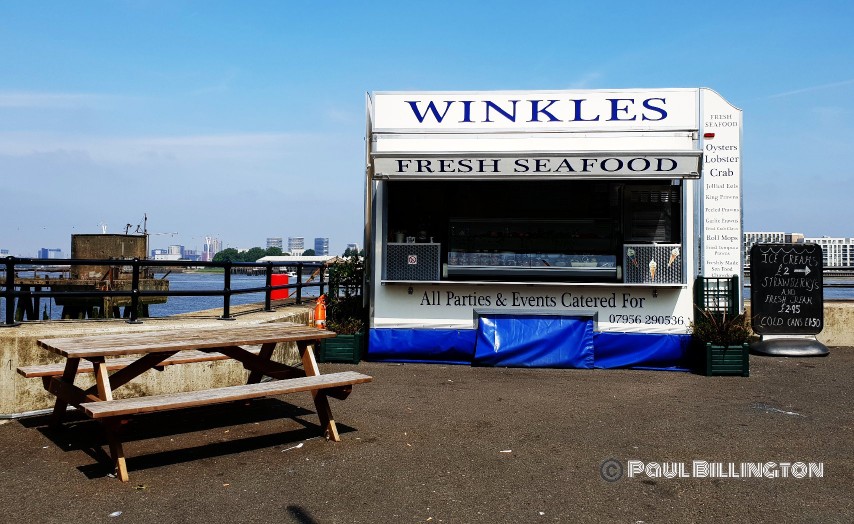
Ah yes. Winkles, taken in 2016; a welcome sight, along the River and in a great spot. Get your fresh seafood at this stall opposite the Anchor and Hope Pub, looking resplendent in dark blue and white these days, well worth a visit; a cracking pub. The current building dates back to 1898 and is largely as it was when built.

A bit further down from the Anchor & Hope are further signs of the historical parts of industry that took part in this area. This is part of Durham Wharf, which still contains disused rail tracks which used to export the contents of coal and sand loaded up to the disused jetty, onto trains that used to run to these parts and joined up to the eastern part of the riverside railway sidings and that onto the mainline via the Angerstein Wharf section.
The riverside lines used extensively by the United Glass Bottle Works, but also served the old GA Harveys site connected up to Angerstein Wharf. These are the last remains of the extensive sidings in the area. The wharf was last used by Cory’s – who remain next door – in the 1970’s.

I took this in 2016. At the time, it reminded me so much of one of those greeting cards with those grey bears on the front, the wooden surrounded even matched the bear like a piece of art. It was protected from the elements, thankfully. I didn’t rescue it….


The very active industrial part of the Thames Path in Charlton comes just north of Riverside where the Aggregate Industries site, which includes Tarmac’s additional plant and CEMEX Angerstein Aggregates Wharf. It is a large site, dusty and dry – so be warned – but it is fascinating to see the container ships taking on or releasing its cargo along the expansive conveyor belt that extends towards the river. The noise is amazing, working river life at its finest. The top picture was taken in 2016 and the lower one in May 2019.

- The other side of the path, into the main site and where the conveyor belt extends across, dropping its contents into the main pile in the centre. The sun catches a gap in the middle of the one of the conveyors and taken in May 2019. To the side of this site is the Angerstein Wharf freight line, which runs at least once a day to the likes of Grain Island, South Wales & Leicestershire.


One of the many developments you will encounter just past the Angerstein Wharf site, leading down to the Greenwich Peninsula and cable car. The first picture was taken in 2016 and the second is of the Greenwich Yacht Club in May 2019, showing the leisure aspect of this area.

Easily missed is a modern take on a sundial designed by Piers Nicholson to mark the commemoration of the 3rd Millennium AD 2000. The grey brick surround denotes that it was presented by the Worshipful Company of Tylers and Bricklayers – of which Piers is a Liveryman – Sir Idris Pearce CBE & English Partnerships.


What has improved along this particular part along the Peninsula is the clear segregation for pedestrians and cyclists. It wasn’t too bad before to be fair, but the clear divide is welcome for added safety and the surface is good. It reminds me of a dual carriageway from this perspective, but there are still works being carried out to the section towards the cable car.


The pace to which the developments adjacent to the cable car have come on, even on the last year is stark. The two above show how they both looked in May 2018. Whilst the larger developed building was relatively complete, no-one appeared to be in situ. The smaller “escalator stepped” building was still some way from being done.
However, the smaller building is still to be complete yet looks nearly there. You will note there is now an additional feature in front of the larger building with trees, which part of a planned 5km raised walkway that is due to open in phases, the first of which will take place in July 2019….

…..named “The Tide” and designed by the co-designers of the Manhattan High Line, it is a riverside linear park with public art installations, outdoor street food spaces and garden jetty spaced over five connected “islands”. The walkway can be seen towards the left, with the glass panelling, extending into the centre of the picture.

Go on then, I might as well put a photo of “Johnson’s Folly” in. You do get good views of the local area in it from a different perspective, although the novelty value wears off once you have been on it. Not so good during high winds either….


I find it alluring how nature manages to effectively reclaim parts that you wouldn’t envisage it to. So, I have included a picture taken in 2016 of the disused Ordnance Pier, which is situated next to the Arora Group Intercontinental Hotel. There were plans by the hotel to create a restaurant and Thames Clipper pier to connect to the other side where a sister hotel is situated.
The second photo, taken in May 2018 shows the vast open space looking out to Alex Chinneck’s “A Bullet From A Shooting Star” – a 35 metre tall sculpture resembling an upside down electric pylon for the London Design Festival in 2015 – it is quite a sight. As is the wonderful Jumbo Gasometer, more on that wonderful delight in a bit….
However, the third picture taken in May 2019 shows the installation of the new Magazine London development taking hold. A new interior space of two Mezzanines, for up to 3,000 people and a further 7,000, taking in Alex Chinneck’s structure as part of the outdoors “Showground”.

Golf anyone? Someone has to collect the balls from the range though….

….or you can always skim some stones into the River.

Next up is the Victoria Deep Water Terminal seen here in May 2019 which has changed somewhat since 2016, you will find my 360 degree picture of this location here. As part of the redevelopment to be a concrete tunnel segment manufacturing facility, with open storage, the waste recycling operation by a third party was terminated.
It appears ships can still moor up, but railings are now in situ as an additional safety measure. The surface is much more smoother along this section – to be fair, anything would have been an improvement though, it certainly added a bit of rugged charm as a walker, although a nightmare for road cyclist – which formed part of the GLA Stage II referral of the site back in October 2017.

You aren’t going to be able to get this close to the edge now. A view from 2016…


As you head around the Hanson site, over the last couple of years and if you used the path regularly, you would have to go on a diversion. Which was a shame because Enderby House is interesting. The diversion would mean you would have to use the road adjacent to the lead up to the Blackwall Tunnel. Not great. But, seeing as I had to go left for a couple of years, let’s go left first. I want to show you a couple of gems….

Affectionately known locally as “Jumbo”, this is East Greenwich’s historic No.1 gasholder, which is approaching 130 years old and is a local landmark in its own right. I understand that the design of the structure was designed by Frank Livesey, the younger brother of George Livesey the South Metropolitan’s Gas Company’s chair.
It is larger than the Old Kent Road No. 13 holder, which it copies and was finished in 1890. Sadly, its future remains unclear – it is still set for demolition – despite strong, local opposition. Hopefully, something inventive to encourage it being kept, akin to those in Kings Cross or even like the one in Vienna, which was converted into apartments and shopping centre, in 2001; can only dream….

From something historic to something that will be a future classic; it is eye catching.
Designed by Conrad Shawcross and called The Optic Cloak, this is the flue to the low carbon energy centre powering the new homes on the Greenwich Peninsula. It is 49 meters tall, 10 meters wide and only 3 meters deep, the surface shifts and changes appearance depending on the light and time of the day.
All the materials are made and built by companies in the UK and it is made of steel clad with perforated panels of aluminium. The fact that the steelworks that fabricated and erected the flue shares my surname (no relation) and based in a Yorkshire town, has nothing to do with it. Joking aside, it is a fine, innovative structure that serves an important purpose in a unique, different and artistic way. Personally, I think it should be celebrated and deserves appreciation.

 ’
’
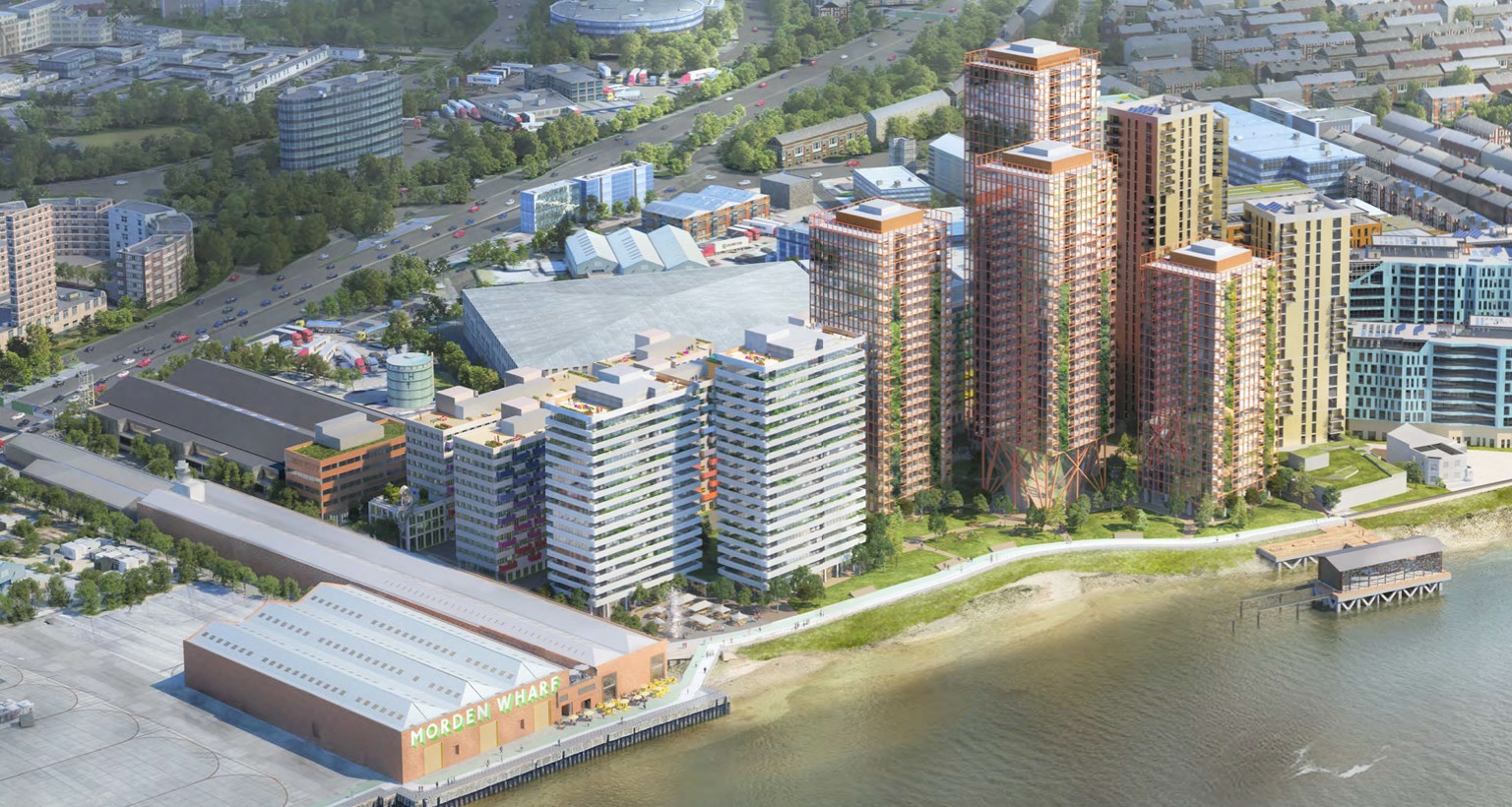
Now, let’s go back on ourselves via that diversion route, before we chose left and head right. Here you will go past some lovely natural shade on the right, ok, you’ll pass what is Morden Wharf on the left – now home to a few buses over the other side of the wall and hoardings – and the security gate to the F-shaped jetty at Tunnel Wharf.


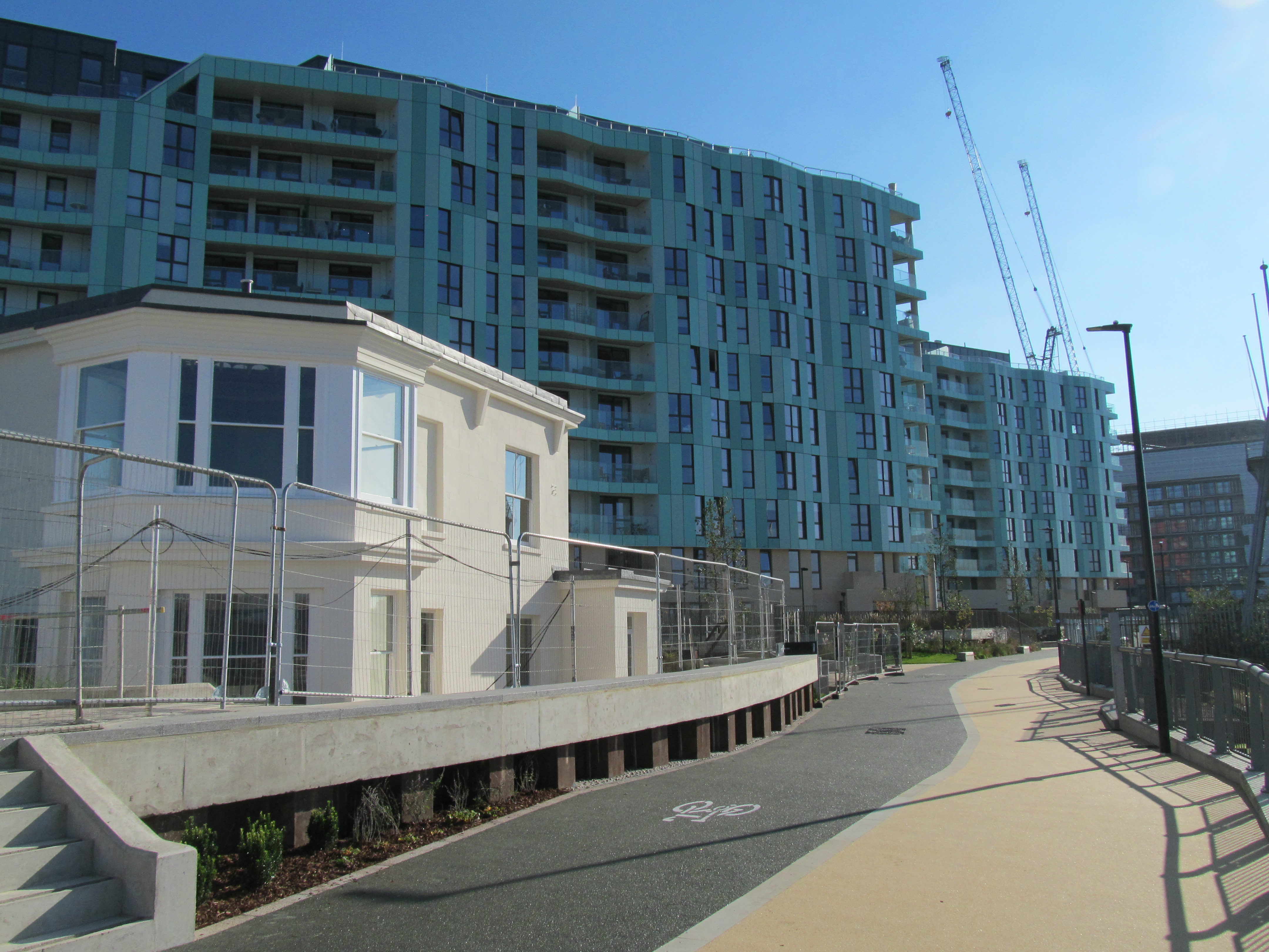
Leading down from Tunnel Wharf, you are immediately struck by the River Gardens development, which is still being developed. More on that in a bit, but it is a sea of green. My eyes. Like the Peninsula, clear distinct walkways/cycle path with plenty of space on either side. The white building is what we come to next…


Nice to see this part of the Thames Path again, but by jove, it has changed a tad. Enderby House is still there, Grade II listed it maybe, but it was looking a bit worse for wear as recently as 2014. So, it is good to see it repainted, done up and surrounded by fencing for the time being. A pub chain had won approval late in 2018 to gain a licence for bar/restaurant use, so we shall see.
The second picture is of the “Lay Lines” public art work the artist Bobby Lloyd. It harks back to the days when Enderby Wharf had a close affiliation to three generations of submarine telecommunications cable systems that were made on the site.
The third picture is of the gates of Enderby’s Wharf with the cable machinery in situ. This site has been much in the news locally over plans for it to be used as a cruise liner terminal scheme, which was abandoned at the end of last year after local opposition and pressure.


The River Gardens development, still a way to go and notable that the retail units – much like those at New Capital Quay were when it was first built – proving hard to let. It could do with a bit more greenery, planters etc. It is very ….empty….and desolate at the moment, which will change no doubt when people and businesses move in. Good that the Thames Path is now re-open along this stretch too. However, the first diversion of the day is down near The Cutty Sark pub in Greenwich. Give us a chance though to see another gem….


Greenwich Power Station is a standby gas, and formerly an oil and coal-fired, power station designed by the W E Riley (London County Council architect) and built in two sections between 1906 and 1910 to provide power for the London County Council Tramways. Power was supplied by coal from Thames Barges and the pier jetty, still visible on the main Thames Path route; work started to replace the coal fired boilers in 1969 and this source of power ceased on 8 February 1972. It is an early example of a steel-framed building with a stone-clad brick skin. The tram tracks are still in situ within the power station grounds as visible in the fourth picture.
It is now used as a backup power station for the Underground via cables to Mile End, Aldgate and Stockwell. In 2015, TfL announced plans for six new gas turbines helping to supply low carbon power for the tube, as well as hot water and heating for nearby schools and homes.


After you head past the wonderful Royal Naval College, the restaurants by Greenwich Pier – the old Frankie & Benny’s still remains vacant, no great loss, had a really dreadful time there once – the Cutty Sark and the Greenwich Foot Tunnel, you approach the New Capital Quay development…
That’s it for part 3. Part four will be online soon. Thanks again to Paul.
Thank you Paul for another very interesting insight to he history along the river Thames and on how things have changed since. There industires along the river Thames and at the various wharfs mentioned employed thousands of people from the Borough, It does bring back a lot of memories. Looking forward to part four.
well, nice IDEA to have a story about a Thames walk. But to add ‘copy right’ (fair, partly) wide over the pics? I stopped seeing the first image as it’s more a self pleasuring ‘article’ than something contributing
Hey Paul, thats really great to read .And congrats for your hard work and thanks infact.
Looking forward to see some more clicks and info in the next part…