Charlton data centre details emerge impacting new homes and transport
Plans for a new data centre to be built in Charlton have been revealed after an early plan was submitted to Greenwich Council.
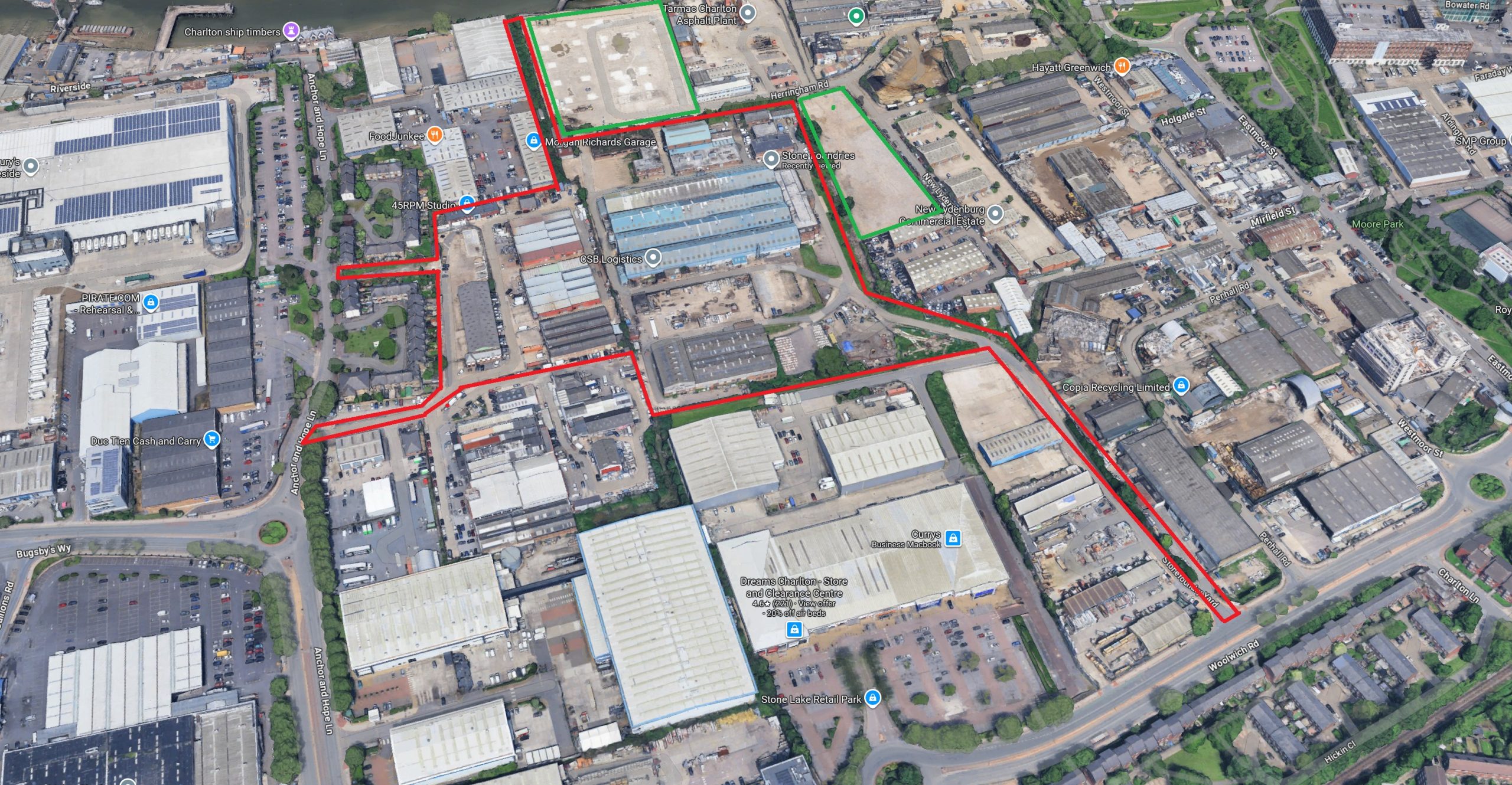
An Environmental Impact Assessment Scoping Opinion is being requested for the site, which would see a “100,000 sqm Gross External Area (GEA) data centre with ancillary offices, internal plant, and substations”.

Located on the Stone Foundries site, it would rise to 45 metres AOD. The data centre would be 30 metres AOD with plant another 15 metres.
The main document states: “There are industrial/storage uses to the south, Anchor and Hope Lane to the west with retail beyond, and vacant/industrial sites to the east.”
Existing homes already exist to the west off Anchor and Hope Lane, while to the north a major residential development named Herringham Quarter has been approved. Alongside a plot to the east of the proposed data centre it comprises 1,212 homes.

Masterplan
Digging out the adopted Charlton Riverside masterplan shows a data centre on site would be some way from what was agreed for the area.
The location in question was to see greenery and new housing to alleviate London’s housing shortage. It’s located in the “Charlton Parks” mixed-use section seen below.

If approved a data centre would reduce the total number of possible homes including the potential for reductions in adjacent areas.
Permeability across the site would also be impacted by a 100,000 square metre data centre, with Herringham Quarter to give one example being “wedged in” between the river and new structure with north-south connections possibly blocked to where bus stops are located, as well as Charlton station.

Plan for area as part of adjacent approved housing plan at Herringham Quarter, which saw through-routes to the south where data centre will instead sit if approved.
Greenwich Council’s Charlton Riverside masterplan stated the area in line for a data centre would be “very much characterised by its relationship with key open space, particularly the new, enhanced Charlton Riverside Park.
“The interface between built form, mostly medium rise apartment blocks, and larger areas of open space will heavily influence the quality and sense of place.
“In addition, this space will act as a link between the Village East and Riverside character areas. In terms of built form, it will share some of the qualities of both the adjoining areas, with a gradient from a more intimate character (and a clearer delineation between public and private space) towards a more open urban grain and a greater mix of public and semi-private space towards the River Thames.”
Transport
The proposal could not only impact housing development totals and adjacent plans for green space but also transport provision for new dwellings.
To assist up to 8,000 new homes in Charlton a major east-west route has been proposed.

In time that could see a system similar to the Greenwich Waterfront Transit emerge, which would not only serve 8,000 homes in Charlton but 20,000+ on Greenwich peninsula as well as thousands more to the east.
Such a direct, fast new transport project may prove a lot harder to implement if a data centre intrudes on the proposed route.
A map of the data centre site shown within the scoping opinion does offer that potential. A final application will show how badly – if at all – it would infringe upon such a transport improvement. Certainly an issue to watch.
If it does, then greatly compromising a transport link serving thousands of homes would in effect block much more new housing, or lead to a meandering, inadequate transport option.
Recent news
Earlier this month Greenwich Council and TfL were raising glasses to an agreement for the Charlton Masterplan area. Few details were forthcoming.

Any revised area masterplan may lead to reduced housebuilding and transport improvements compromised if a data centre rises.
The applicant aims for an overall construction period extending from 2028 to 2033, with commissioning of the final phases anticipated in 2033.
Greater London Industrial, which is behind the plan, state “the proposals also include significant investment in landscaping and green space, and support for new transport infrastructure and pedestrian routes across the site.
“As you’ll be aware, viability has been a major problem across London in recent years and our plans are intended to support the deliverability of residential development on nearby plots through the provision of new infrastructure.”
Waiting game
Further details will be eagerly awaited to see if landscaping is much more than shrubs surrounding a large box-like structure. It’s hard to see how pedestrian routes as previously envisaged can be accommodated through the middle of the data centre site linking approved new homes to Woolwich Road.
I could see Greenwich Council saying “the Thames Path is there” as a get-out when looking at access for approved new homes directly north, but that’s in the opposite direction to Woolwich Road.
Greenwich Council do have form in doing that, such as when they ignored suggested street improvements from TfL using S106 revenue obtained via a recent West Thamesmead development. Rather than invest in improving the obvious, logical walking route to Woolwich station it was instead suggested that new residents use the Thames Path to head west. Except it wasn’t really in the right direction and leads to a more circulatory and slower journey.
When it comes to housing viability at Charlton for future sites and whether a developer can make a return on a plot, would housing plots beside a data centre help that? It’ll be a tough sell.

As for transport costs such as buses routes through the site, the developer will have to contribute Community Infrastructure Levy and Section 106 funding – as other development does – but would it be enough to mitigate any intrusion on the proposed east-west spine route which is essential for the wider 8,000 home plan as well as linking the area to Greenwich peninsula, plus a potential loss of walking routes if indeed that is proposed?
That could again impact how viable other plots will be if estimated sale prices are impacted.
All eyes now on any consultation documents and a full planning application.
UPDATE: It appears generators for the data centre would be located close to where the main east-west public transport route is supposed to go.
In addition the same applicant secured approval for a project last year which also hinders the route. This is a key link serving up to 8,000 homes and crucial for the wider masterplan’s success.

Whilst it doesn’t make it impossible it certainly isn’t helping. The direct transport route previously agreed would instead meander and require land purchase at other plots.
A sub-station would be located on the west near existing homes.
They’ve attempted to soften the transition from data centre to approved homes to the north via lower rise blocks but no direct north-south through routes on foot or cycle are shown as seen in the masterplan.
This isn’t the final submitted plan but appears to be the latest thinking according to this website.
Still, looking at the data centre website and the proposed site plan it appears detrimental to a number of key council, mayoral and governmental aims in that it restricts housing, limits previously agreed walking and cycling routes from new homes and perhaps most seriously it hinders a proposed public transport link which is essential to serving thousands of proposed homes.
Oddly they’ve claimed it results in “delivery of improved transport infrastructure, supporting RGB’s ambitions for growth at one of the Borough’s key site allocations”.
Put it this way, a 301 bus extension to Charlton isn’t cutting it alone and is far from enough for 8,000 homes, so if there’s any seriousness about building homes in London this project isn’t helping.


Hi
A Data Centre sounds just like a building but no mention of the electricity usage water usage and noise pollution ….these close to Housing will be an issue
100,000 sq metres 45 metre in height…is no blip on a map…
And throwing green space under a bus is the Greenwich way of progress
If this gets the go ahead that’s it for thousands of homes in the area which means fewer shops and jobs in those fields. It’s hard enough to build homes as it is but no site will be viable when it is dependent on selling/renting to people who will be positioned beside a vast, 24/7 humming data centre at 45 metres in height. I can’t see any one buying or renting with that next door let alone if it cuts them off from transport links as homes would lack parking.
Data centres don’t even directly provide many jobs. This will be an interesting test case for the local authority and government. They state they want housing but also seem entranced by AI and the big tech companies who are betting the farm on it (and so need land for data centres).
What wins? Housing need or big tech business?
No mistaking that an AI data centre would make what’s already a tricky master plan area all but impossible to deliver to a satisfactory degree. It’d be so heavily compromised any homes that are built (which would be few in number) would be cut off and inadequate both in living conditions and appeal.
Aside from whether an AI data centre is inherently a good or bad thing (that’s a massive argument right there!) this hardly seems the correct location for one given prior approval of housing directly beside it on two sides. I can’t image Hyde are happy about it as it’ll render their housing project dead in the water. Herringham Quarter to the north is constrained by the river to one side then a data centre to the south. To the east is the concrete plant leaving the west as possibly the only usable route, but one that is not direct to bus stops and some amenities.
Urgh this is a litmus test of how seriously government at local (and national?) level take housing delivery. The local MP is a housing minister let’s not forget!
Approve a mass box data centre in an urban area near stations and it shows true intent, as this is one of the few areas suitable for large-scale housebuilding in the borough. This isn’t just any ex-industrial site but one clearly chosen as a future housing site through years of consultation and planning. Throw that out and what’s the point? True its been slow going so far on the Charlton SPD but it certainly isn’t going to be helped by this mass intrusion plopped down to the detriment of the areas redevelopment plan.
Five years of construction works (polluting!). Their initial off-site construction and materials extraction (polluting!) An ugly mass (and make no bones about it, it will be ugly; they all are) in the midst of new modern housing and green space, emitting pollutants and extreme heat from their ‘huge’ cooling systems. A ‘massive’ drain on the local energy network, which is sure to cause regular crashes in peak periods, will need more cabling and more road disruption from the works. Data centres, which in themselves command enormous volumes of cooling tapwater/drinking water. When we are heading for long, frequent periods of drought regularly, in all probability. With water shortages in the S.E England and S.E London area already highly likely, with desalination plants either not yet built or broken, as is the case of England’s only current one! The humming noises once operational will drive locals loco! You need only look at similar, already operational, centres in the US to see what effect on nearby residents these centres have had. Why here in dense urban centres? Has to be a cost reason of course, at the expense of people who buy, rent, and bring up families here. Council MUST reject this wholeheartedly without the chance of a new revised application. City Hall (if referred to them ) I’m sure would not and could not legally approve, considering their net zero goals for London. Or if approved, may face a legal battle from conservationists/environmentalists, who are on the side of the local populace in this. Be brave and make it an open-air green space with sporting facilities to keep our kids off the streets and reduce crime in urban areas. Worth more than money can buy. And I hope local councillors are reading this too! Are you guys??
I attended a meeting about the Charlton Riverside statutory planning document and remember all the talk as it was drawn up over years. It’s all moot if an ugly sprawling faceless massive box arrives on the middle. And we know that is what it will be. You can’t sugar coat a structure of this size and magnitude.
Therefore if approved it rrenders the wider plans null and void. Did RBG knew of this when they put out a news story about “exciting” plans for Charlton recently (it was on their email) which begs the question of whether those exciting plans include this centre, and have they decided to drop the well designed prior plan that was painstakingly arrived at, and finally seemed to gather momentum with plots being built and others approved? What do the council leadership know? When will plans be revealed? Is there a consultation? And what’s the point anyway as agreed ideas for well designed new home layouts and form located among new businesses and greenery get thrown out when big business comes knocking to put a bloody great big box in the centre.
A proposed east-west spine link for public transport through the site is even more essential now to accommodate up to 8,000 houses as Woolwich Road is seeing dedicated cycle lanes installed. I support that but it does limit road space which could be a big issue with up to 8k homes and employment uses right beside. There’s only so many buses you can get down it not to mention general traffic, deliveries and similar uses.
There are images of their plans here https://www.charltongateway.london/ but being CGI take it with a dash of salt. Approved and existing homes are located nearby and any 24/7 noise from the site as appears to be the case at other data centres won’t be pleasant.
It talks of “financial contributions to improving local bus services and cycle infrastructure” but if they build so as to prevent a new public transport link road (rather than what looks like a small access road) that’s to the detriment of huge numbers going forwards as plot after plot is developed.
As for cycling, again the images are nice but losing key direct routes seen in the masterplan is not good enough.
Thanks it certainly looks like the main public transport east-west road won’t happen. Oh dear. Generators would be located where it should be. That’ll be a massive problem down the line. It’s crucial for the wider success of the plan. It’s not completely impossible to do but this proposal certainly isn’t making it any easier.
Also the substation is closest to existing homes on Anchor and Hope Lane.
There are 2 schools within this vicinity. Should not be allowed. What ia health impact to students and adults living near there. Need to be protesting to this now. Should not even be considered.
Datacentres have health impacts? Please do elaborate on what they are?
They keep severs cool by pumping the heat outside – if this is a 180MW data centre, thats the equivalent of 90,000 household electric heaters (2kW each) … and putting all that heat immediately outside.
And in a power cut, will they switch to battery or polluting on-site diesel generators? Would be worth finding out!
A masterplan is only worth its first contact with reality and Greenwich have already blown it by letting a well thought out grid of routes across the area for pedestrians and public transport be tarnished with agreed applications. Then again should it be down to them? A strong public body should be overseeing progress in a holistic manner and not allowing individual applicants to ignore what as agreed. It looks like the authority are belatedly doing something but the horse has bolted. The core principles are undermined already. If the data centre as seen is built its the nail in the coffin. A thoughtful, well integrated and well connected potential neighbourhood is not possible.
These things take huge amounts of electricity to power. Noise is an issue for those living nearby. It’s not suitable for a site beside existing homes and in the middle of one of London’s proposed main housing spots.
Their impact can be read here: https://www.eesi.org/articles/view/communities-are-raising-noise-pollution-concernsabout-data-centers
https://www.theguardian.com/commentisfree/2026/aug/09/slough-famous-the-office-datacentres-locals-hub-europe
I don’t think the website has been laid out in the best way, but from ‘The Site’ page and the images inside it looks like the plan *is* to build a public east-west access road through the site that can take buses, and to support the extension of Herringham Road to the west – this isn’t (as I’d first thought) a total lockdown of the site for industrial use, and I guess building this gets Greenwich 1/3 of the way to their new route. If I were Greenwich I would be looking to get ownership of the limbs to the North and South as part of the deal to help with future land assembly.
I have to say I’m not opposed to something like this being here. But having said that, the proposal looks like a business park and I think the site could take on a much denser approach reflecting that of what should be a new town centre; active frontages, commercial uses on the outside of the main building, and residential infill between the site and the existing low-rise nearby. And of course, real forethought as to how the future road network (including potential BRT/Tram routes) will be laid out.
Maybe you could have the main building put in place as-is with space around it to extend out in the future (like e.g. the Woolwich Elizabeth line head house), and then fill out some of the green space around it as a more central park is created in the masterplan.
I was looking again and there’s a plan here. Zoom in on page 5 and doesn’t look like a road for buses but access to parking and a loading bay to the south of the site. https://wp.sirendigital.uk/gldc-spacedc/wp-content/uploads/sites/14/2025/06/Charlton-Gateway-Prime-East-London-Powered-Data-Centre-Site30.pdf
Thanks I hadn’t seen that – I stand corrected and that goes against the images which show what looks like a road with public access.
In which case, this is a very poor use of land, and I really hope the new transit corridor is not just something that meanders up and around and back down Herringham Road.
You could rearrange the site quite easily to fit all the buildings and access in the top-left corner of the site, with a taper down to Derrick/Atlas Gardens, access through the middle of them, and leaving space for residential blocks and streets including an east/west transit route on the right and south side flanks.
It’s been designed like a business park to be built as easily/quickly as possible, with a green ‘buffer’ which is inappropriate for what should be a dense residential/town center site, and nixes the potential for a quality transit route which is badly needed. I hope that Greenwich can constructively oppose this.
See the Derrick and Atlas Gardens Residents’ Association – DAGRA – has long been active on this matter . All power to them !
Mayor of London will have influence as may /will central Govt.
If a planning application is refused by Greenwich Council ( assuming one is submitted) then the applicant can appeal to the Planning Inspectorate and beyond that, if it is again refused, the Sec of State may get involved.
This is going to be a very ,very long campaign.
Has the option of building this data centre below ground level been looked at then all the waste heat can be used for heating etc in the winter for housing units built above and fed to local schools etc plus energy transfer for summer cooling.
If the centre is below ground the noise issues will be overcome, the waste heat will be recovered and but to good use and not just pumped into the atmosphere or the Thames to add to global warming and public park / transport links can be opened up between say Woolwich and North Greenwich away from the congested lower road.
Just a thought 🤔
Don’t the lives and well-being of the residents of Atlas/Derrick Gardens count for anything? This development is way too close and the disruption will drag on for at least five years.
it is nowhere near getting planning permission – the planning application has not yet been submitted.
The local residents seem well organised with many allies far and wide. See story in Guardian about a planning application for a data centre in Ockenden in Havering .
I’ve just had a read about that one. The Charlton plan is more egregious to this government and council’s stated aims given its on already allocated brownfield land for housing (which we know this government has been stating is a key aim) and compromises a key planned public transport route serving said housing.
I’ve just had a look at the draft Greenwich Local Plan – interestingly the section for Charlton (pg 95 onwards) places this site as a ‘Strategic Industrial Location’ intended just for dense industrial use, with no plan to introduce an east-west route through it. The intent would instead be for the ‘riverside bus route’ to go up Herringham Road from Woolwich Road and back onto Bugsby’s Way, and to have a a high street of sorts below it. The proposal here is technically an improvement on that plan, as at least part of the site is opened up to pedestrians. I can’t say I’m pleased.
Smacks of Greenwich Council rolling over to certain financial interests. To the detrimental of earlier plans for new housing and crucially key transport links.
All eyes now on the Environmental Impact Assessment Scoping Opinion which Greenwich Council must provide by 11 September having consulted other statutory bodies such as the Environment Agency , TfL and Historic England.
I find it strange that no one has thought of using the vast amounts of heat generated by Data Centres thus requiring water to cool them to have the water heat the nearby homes being built, at little or no cost.