Has Crossrail work revealed a long hidden river?
The long-hidden River Wogebourne, or Wickham Valley Waterway, may have been revealed as Crossrail construct new lines between Abbey Wood and Plumstead.
The river begins in Shooters Hill and snakes its way through Plumstead to Abbey Wood before reaching Thamesmead. Most has been progressively covered over the years and there are now few signs of it running above ground.
Passing by on a train a couple of months back I noticed quite a bit of water in a new ditch being built alongside the line. I assumed it was just run-off from rain, and forgot about it. Recently I read this brilliant article by the e-shootershill blog on the history of the river.
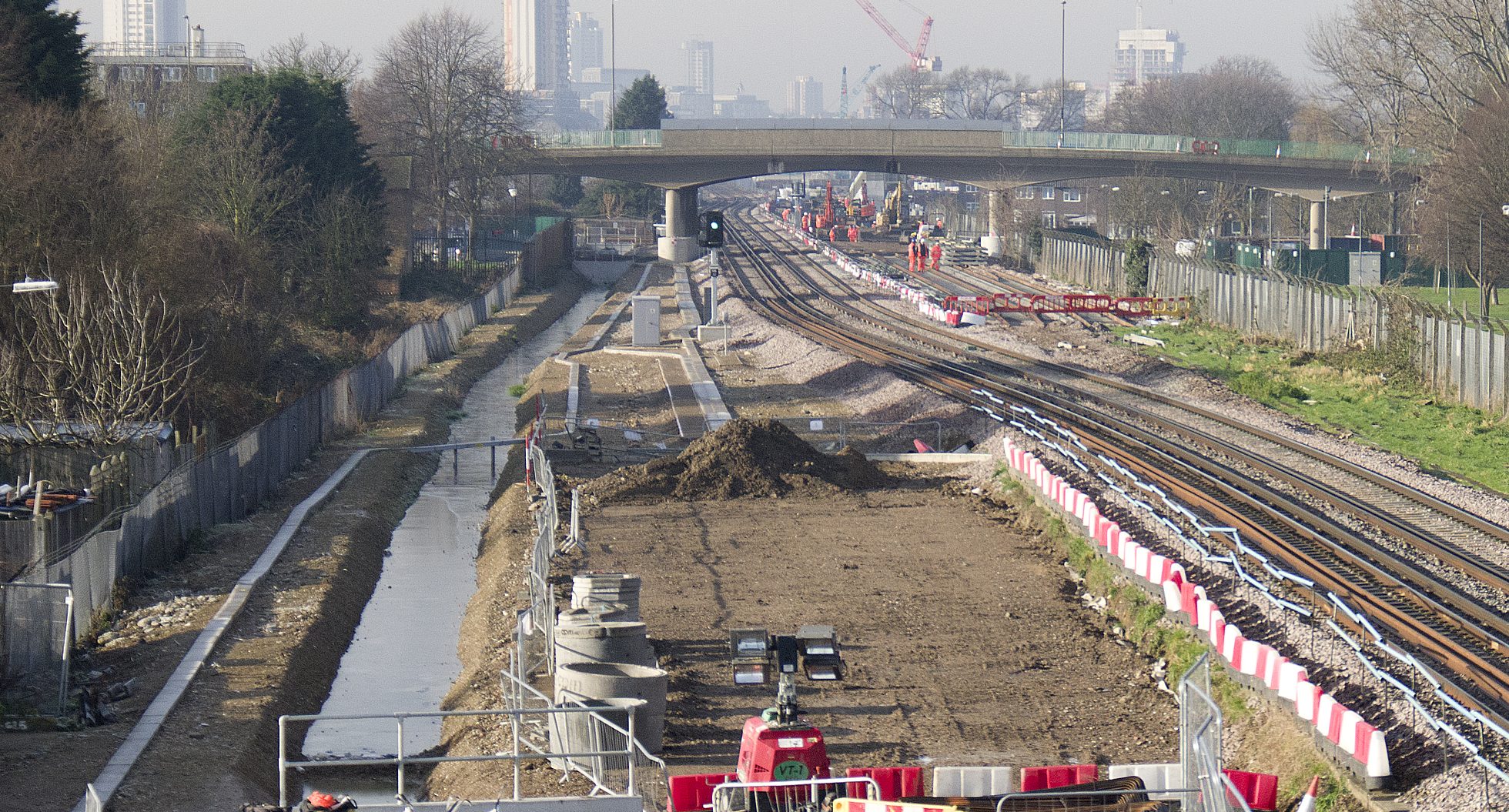
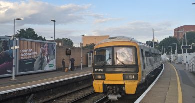
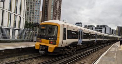
I still didn’t put two and two together until passing through again recently and seeing a lot more water for quite a distance alongside the tracks, as shown in the photo above taken by Bexley-is-bonkers. I suddenly remembered the article and that the river led through to the area around the railway line.
Where the stream appears to end is around an area where some Crossrail work was recently being done under the tracks. I assume it enters a pipe at that point.
The source
The river begins around Shooters Hill near Woodlands farm and the We Anchor in Hope pub. The river passes through Bourne Spring Wood and then heads towards Bostall Woods, before heading roughly parallel to Wickham Lane before heading below ground under Bostall Hill heading down towards what were marshes at Abbey Wood and Thamesmead. The e-shootershill article shows photos of the course in the few sections still above ground at Woodlands Farm and Woodbrook Road. The article states in the sixteenth century:
“W.T. Vincent called it the Plumstead River, and also “An Obsolete River” which had disappeared. He said that it flowed “from the Halfway House, near Crossness Point up the Wickham Lane Valley, a short branch diverging eastward to the point where the abbey of Lessness stood (near Abbey Wood Station), and the other stretching past the eastern foot of Shooters Hill through Well-end (Welling) to Eltham.” He also mentions that it was connected to the “Great Breache”.
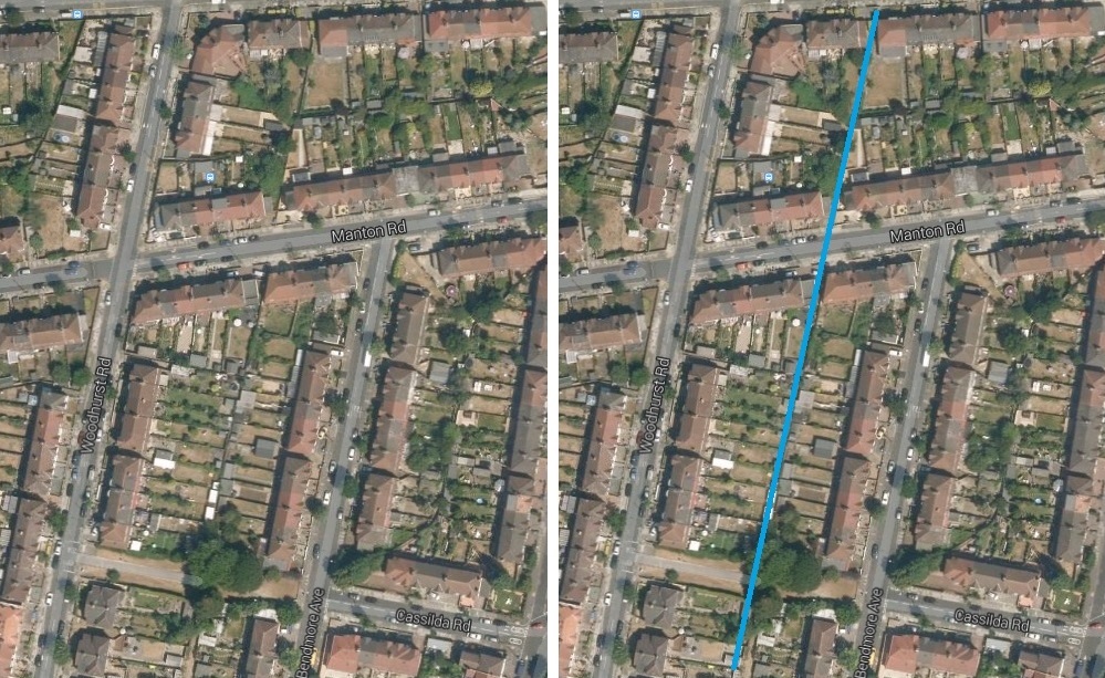
It was far from obsolete, though often more of a trickle than a river. It was still visible in parts of Abbey Wood until the ’70s. The two aerial images below show its course, now entirely covered. Google satellite images clearly show what appear a straight line and gaps between houses on Manton Road where it runs.

Greenwich Council commissioned a report in 2011 on strategic flood risks, which can be seen by clicking here. This report refers to it as ‘Butts Canal’ and states that the term ‘Wickham Valley Watercourse’ is used informally, but other sources refer to Butts canal as only applying to its final course once it reaches Thamesmead. The report contains a map showing the water course’s flood extent, which may not match its exact course but shows the general route:

The railway line runs across the map at the far top. The path of water revealed by Crossrail is along there. I assumed any stream currently ran to the north of the railway line as there’s features and manholes running along there like this –


Another map in the report does appear to show that the river ran north of the line, instead of south as the new watercourse revealed by Crossrail work. But it could switch across part way along Mottisfont Road in Abbey Wood.
This map from the 2011 report labels it as a “main river”, though long buried below ground.
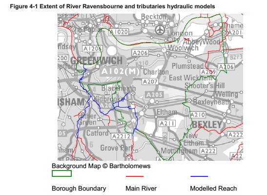
The red line clearly shows it north of the railway line, where it runs next to the railway line towards Abbey Wood station (which is being rebuilt and where large storm drains appeared to be recently installed ) before heading north towards Thamesmead.
Crossrail referred to it as a stormwater drain in planning documents:
“Wickham Valley Watercourse is a piped stormwater drain which crosses under the Crossrail route between Plumstead and Abbey Wood Stations from south to north. It runs parallel to the railway for several hundred metres before turning northwards towards its outfall in a lake, which feeds through one of the Marsh Dykes to Tripcock Pumping Station”
A Crossrail planning document of the area also shows ‘relocated culvert 615’ north of the line.

Crossrail also state:
“It is not classed as a Lost River, although similar in form and history, since it is now the responsibility of the Borough Council and not Thames Water Utilities or the Environment Agency.”
Before extensive drainage works at Thamesmead in the 1960s and ’70s when the lake and canal system was constructed, it would have have presumably ran from Abbey Wood into the marshy ground by the Thames at the site of the ‘Great Breach‘.
An extract from 1596 mentions the great flooding that occurred.
A Bexley Council report on Southmere lake states:
“This whole area, close to the Thames, used to be swampy ground, known as Plumstead Marshes.
The lake was constructed in the late 1960s at the same time as the first part of Thamesmead. It was only possible to build housing and roads here on this swampy ground by doing major drainage works.
Now the lake is a crucial part of the drainage system: it is the head feeder for all the canals in Thamesmead. A constant flow of water comes into the lake from the south, from a little stream which rises in Abbey Wood (and travels here underground in a pipe). It leaves by a channel in the north east corner and flows to the Thames.”
So if this stretch of exposed water is the little known River Wogebourne, or Wickham Valley Waterway, it’s the first time it has been seen in Abbey Wood for many a year. Presumably not for long either, as construction work continues apace along this stretch and this section will be covered over once more.
May 2019 update: It was indeed the River Wogebourne. This page details how the contractor managed to adjust its flow as new rail lines were built. It’s now once again covered and unlikely to ever be seen.
- You can support me and the site by donating here via Paypal or Ko-Fi.
- Or become a monthly Patron here.
- I also have a Facebook page for news in your feed.
Running a site alone takes time and a fair bit of money. Adverts are far from enough to cover it and my living costs as a private renter.
You can support me including via Paypal here Another option is via Patreon by clicking here You can also buy me a beer/coffee at Ko-fi here There's also a Facebook page for the site here Many thanks

smashing read and perfect timing as I was doing some general digging about the Plumstead river last week.
Very interesting! I too just thought it was a ditch, wouldn’t have guessed it was a hidden river!!
Pingback: Weekly round-up of London’s railway transport news
The river wogebourne runs under my garage forecourt and if I lift the cover up there is a fair flow of water handy for sweeping snow down in winter.
I’m just about to buy a house in Abbey Wood. Should I be worried?
Yes, but for very different reasons.
Pingback: South-East London’s lost river revealed again? | fromthemurkydepths
I remember a small stream running in a ditch adjacent to the north platform of Abbey Wood from many moons ago. I always wondered what happened to it (where did it come from, go to, etc.)
Me too. I assume water pooled there as marshland was in the area and now modern drainage systems take care of that.
Bloody Brilliant! I’ve always wondered what that little stream was in Bostall Woods!