Woolwich upgrade project creating problems near Elizabeth line station
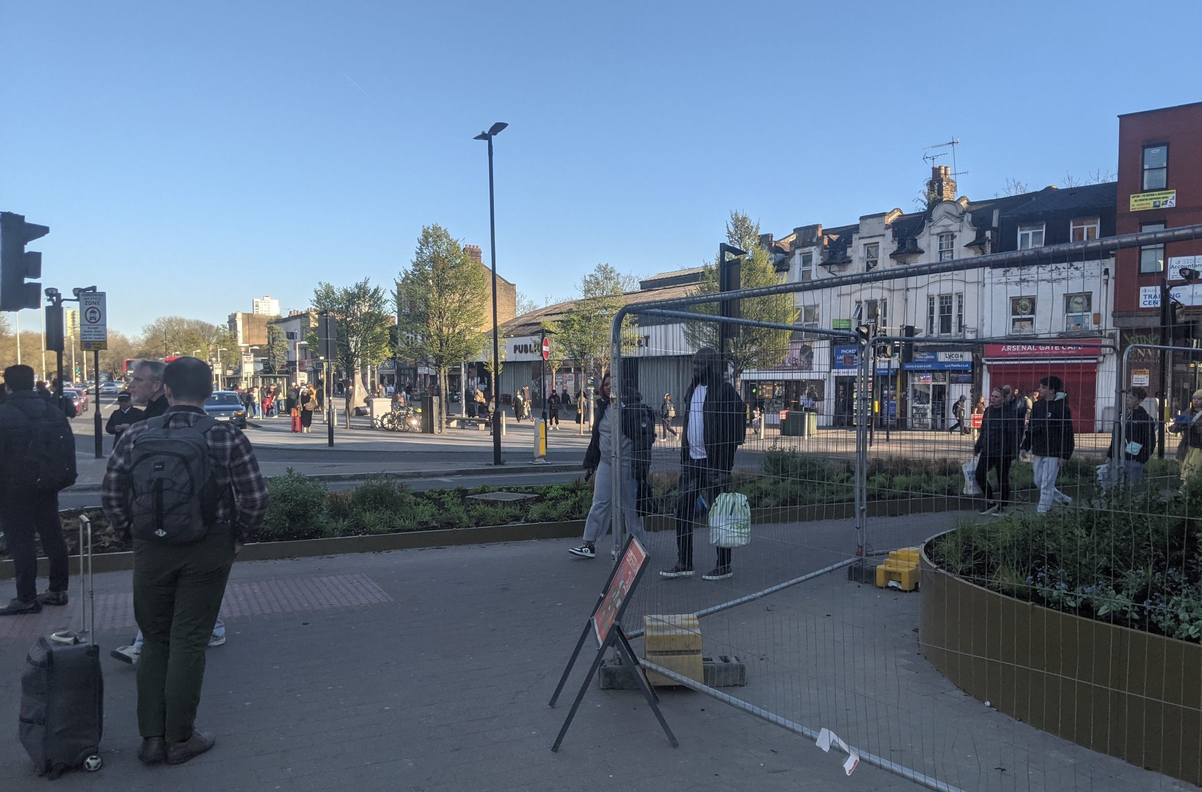
Work on a £21 million Woolwich town centre project has recently moved over to an area near the Elizabeth line station – and is currently busy greatly reducing usable paving space for pedestrians in a highly trafficked area.
Reduced paving space is being implemented on the main route between both the Liz line station and Royal Arsenal and the town centre with its Southeastern and DLR station.

In a bizarre move Greenwich Council are installing numerous raised planters greatly limiting usable space in a very busy area, in the process creating numerous pedestrian pinch points and areas of congestion.
It’s the kind of design that looks wonderful in renders, lovely on a quiet night when no one’s about but an absolute hassle to traverse during most of the day.

It fails the practicality test immediately when any sort of pedestrian flow appears – and this being a town centre location near some of London’s busiest stations and bus stops is most of the time.
Whilst this site has long reported plans to reduce space for pedestrians around nearby busy bus stops, these works to the east weren’t clearly highlighted.

Temporary fencing exacerbates the current issue though even when gone we’ll see severely reduced space for those on foot.
People with limited mobility will be particularly badly hindered. Two minutes spent watching and it’s clear this is flawed.

Desire lines will probably appear with new planting trampled as people seek to cross the space and head across to their destination – and you can’t blame anyone if they do. This sort of stupidity in design puts pedestrians last.
If people don’t walk over planting they’ll alternatively head into the busy road to bypass crowds.

Increased footfall
The problem will only grow as a huge number of new homes, shops and amenities are proposed in the immediate area substantially increasing footfall in this area.
To give an idea, here’s what coming nearby:
- Woolwich Exchange (802 homes, shops and a cinema)

- Poundstretcher site redevelopment
- Two student blocks over the road – 400+ rooms
- Berkeley’s Ropeyards site further along Beresford Street – 660 homes
- MacBean Street development
- Riverside House conversion to hotel and student rooms
- Woolwich towers beside River Thames
- New leisure centre and eventual housing plot to the rear
- Mortgramit Square development
- Woolwich Central (just now commencing)
- Brookhill Estate rebuild
All can be expected to lead to greater flows across the town centre including through this newly, narrowly constrained area.
One of the few less likely to is Armourers Court approved above the eastern end of the Elizabeth line station as residents there can use a crossing to the east.
Transport for London project
To throw a further spanner in the works TfL plan a cycle lane past this point.
Render released by TfL fail to show extensive space given over to landscaping in the area.

Are they aware? One wonders about the foresight given what’s already being undertaken.
There are plans to move the main pedestrian crossing across Beresford Street and open the central arch of the Royal Arsenal Gatehouse yet this won’t remove fundamental flaws which hamper the flow of pedestrians.

Take the image above. People leaving the Elizabeth line or Royal Arsenal and heading to Woolwich Arsenal station will want to walk straight ahead here and not meander through the Gatehouse then Beresford Square.
Same goes for those heading to Tesco or the new leisure centre.

In the above image if you leave the station and want to reach a future major development proposed just ahead at MacBean Street the options are narrow paving behind the cafe or walk in the road/future cycle lane.
We’ll end up with tiny slithers of paving at this rate as thousands of new residents move into the area.

If new shops and a cinema are built that’ll attract more people to Woolwich to boot all adding up to create packed sections of paving.
Removed?
Don’t be surprised if it’s all ripped out in a few short years. Remember Woolwich has plenty of form for this.
A green central reservation nearby lasted about five years before being tarmacked over. It was never maintained nor cleaned of rubbish.

The adjacent Beresford Square’s recent revamp lasted barely a decade before all being ripped out.
Powis Street is now on its third major change since the 1980s. That 1980s revamp had many raised planters which didn’t last long.

The council’s HQ may be in Woolwich but scant evident many senior staff actually travel around the town.
Greenwich have a fine record of installing town centre public realm projects without much clue how they’ll work in practice or be maintained. This again looks like following that same (narrow) path.


Arghhh one of my big bugbears at the moment. Walking this way was always a pain but now is 10x worse as everyone jostles at busy times and its s cramped. My mum with a bad hip was getting pushed out the way as so little space to pass. Simply terrible design. Then you have all the shops leaving rubbish and boards outside which the council do NOTHING about. For all their droning on about people going green and being active blah blah they don’t even do the basics of keeping busy routes clear.
In Woolwich, pedestrians are mostly pushy animals. No amount of lipstick will render the pig less ugly… and since I mentioned that word (pig), the revamp was always going to be casting pearls before swine. Could people not be a bit more considerate and walk slower minding other people? Of course not, too busy checking their phones. Now it turns out we need more walking space..? I wonder, why bother..? This country is going to hell
I don’t mind these planters where they are. I’m a frequent commuter going down Woolwich New Rd across to the Lizzie Line and reckon once the fences are out the way it won’t be too bad. The main issue there is the scaffolding outside the Old Gunpit taking up the pavement!
As for the parking spaces, if I’m sat outside the new cafe I’d much rather look into flowerbeds than parking spots.
I do share your dubiousness on the council’s abilities to maintain it…
In regards to car parking I didn’t mean there should be parking near the cafe but that Beresford Square was being used as a car park after the last upgrade (which it wasn’t supposed to be) as little maintenance/enforcement.
If you don’t mind these flower beds you’re possibly not disabled like myself! I need to use a stick and walk slowly these days and previously could stand back from crowds near the gatehouse when waiting to cross the road. That area is now gone and I have to stay amongst all the people gathering in the reduced area around me who are rushing to and fro from the station and it’s horrible. Very anxious now. Was an impact assessment carried out on how this impacts disabled people like myself? It looks nice but really makes this stretch horrible if disabled.
I have complained numerous times to the council about the shops on both sides of Woolwich New Road between the DLR Station and the Elizabeth Line station. The spill their ware out for free really estate on both sides, and leave rubbish. Remember how they gave themselves a pat on the back closing down the mirror shop in Charlton? The footfall here is considerably more. Doesn’t help that the buses all drive drown here like they are trying to achieve a qualifying time for Silverstone.
I can only imagine how much more difficult it is for disabled people which I have told the council as well to deal ears.
I am surprised there hasn’t been a fatality here yet with a pedestrian and traffic.
It still looks lovely and hopefully the plants establish and are *maintained* but I agree the paths are now too narrow.
You forgot the Island Site as a nearby planned development 😉
I realised that an hour after! It’s been around so long waiting for anything to happen it’d passed me by. Could add in the DLR sites too when they’re finally developed.
Isn’t there a plan to improve the direct route between the stations used by many and create a safe crossing near M&S.
It has been mentioned by TfL/Greenwich they’d be one that side though details on TfL’s consultation into street changes shows one either side and renders show the existing crossing in situ. Woolwich Exchange work will limit paving space on the eastern side of Woolwich New Road during construction to boot. It’d probably have been wiser to not install many flower beds and raised planters until nearby construction completes. I understand external funds have deadlines but spend elsewhere (eg eastern end of Powis Street, the link between Powis Street and Sainsburys etc) and come back to this area in a few years. Any work could then be funded by forthcoming CIL/S106 or further external grant bids.
If they do make just the one crossing outside M&S the planters/beds still obstruct pedestrians coming from future sites the other side of Beresford Street such as Macbean Street, Riverside House, Poundstetcher redevelopment and Mortgramit who may walk over the planting or into the road/future cycle lane to reach the crossing. It’s such a high footfall area all obstacles have adverse impact.
Correction: they don’t travel around it on foot, but in a car. The modifications seem to make sense if you want to dissuade pedestrians and make it look good for motorists. As you say this doesn’t make sense for the thousands without.
Although this is better without fencing now, the only way this makes sense is if the second pedestrian crossing is introduced nearer to M&S soon.
People are still chancing it across the wrong side of the intersection, and someone is going to die at this crossing, it’s simply a matter of time. Two motorcycle accidents and a woman was hit attempting to cross the road further down. Frankly its close to requiring something like a subterranean tunnel for pedestrians to the city centre, or better yet a tunnel for cars from Burrage to Macbean
I think that the idea is that when the gate house opens people will walk through the middle of the square .also the works on the ordinance pub don’t help at the moment. We will have to see if it works when the square opens.
You’ve totally omitted the pedestrian rat-race to get from the bus stands by the Public Market over to the Liz Line. You’ve got about 5 secs before the eastbound buses from Woolwich New Rd get their green light. I think that timing has improved lately but it’s still a rat-race. There does need to be a light-controlled pedestrian crossing there.
Planters are always in the way and always unmaintained after a few months or years. Archtietcs really need to think about the future
I love th3 idea of all the changes but as usual, disability is an afterthought, a bit like Greenwich councils ability to maintain infrastructure. I’m hoping for the best but expecting mediocre Input after the works been completed.
They’ve clearly been put there to stop people running across the road at places other than the crossing. I’ve seen SO many people nearly get hit by speeding cars there and there have been so many accidents, I can absolutely understand why the planters have been put down to limit this. Is it inconvenient? Yes. Is it busy? Yes. Is it better than someone getting killed or hurt every other week – definitely.
RS – That seems to be the intention but now people are walking in the road to bypass them which is even more dangerous than having sufficient pavements for the area. Seems a poorly thought out “solution” without changing the entire junction first.
As a resident of Bentham House flats on Station Way, residents havehad to put up with the site owners ‘Berkley, closing Arsenal Way, for the past 3/4 years. At first their excuse was that the road space was needed for the construction of their block of flats. Now all construction work have been completed, for the past six months. It is clear that they are keeping a few pieces of junk in it.
Berkley management says that ‘the Elizabeth line’ needs this place to be kept closed. TOTAL LIE. Elizabeth line have a vast area in their property next door.
Greenwich council must instruct ‘Berkley’ to remove the Arsenal Way barricade immediately